Water cycling (hydrology) in the headwaters
An important goal is to understand how water moves through, and flows from forested watersheds and how different kinds of forest disturbances change the water cycle. The hydrologic cycle in forests is governed by the interaction of climate, vegetation, and soils/geology to regulate the amount and timing of streamflows. Rain or snow falling on a forest may be caught by the branches or leaves of trees where it evaporates (interception), stored in the soil and used by plants (transpiration), or evaporated from the soil surface. Water that is not lost to these evaporative processes generally flows subsurface along with groundwater to become streamflow.
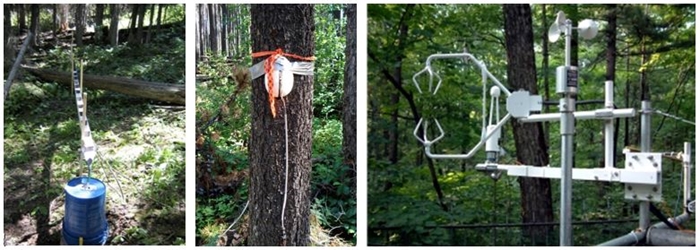
A broad network of climate stations is being used to monitor key weather variables (air temperature, wind, relative humidly, radiation, etc.). Radio towers (30-50 feet high) are installed at each gauging site and equipped with cellular telemetry systems for remote data collection. Hydro-climatic variables are recorded and stored on electronic dataloggers for manual or remote downloading. Universal precipitation gauges are used to measure precipitation both in the form of snow or rainfall. Snow depth sensors continuously monitor snowpack accumulation (winter) and loss of the snowpack during spring. Broader snowpack surveys are conducted to develop a better picture of how snowpack conditions (depth, density, and snow water equivalent) across the watersheds.

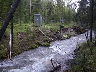
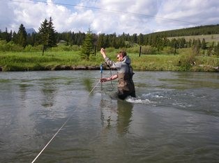
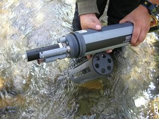
Streamflow is monitored across a broad network of hydrometric stream gauging stations using standard stream stage-discharge relationships at all of our research sites. Manual streamflow measurements are conducted with standard area-velocity techniques using flow velocity meters. Current metering is performed approximately every 7-10 days during the snowmelt freshet and at 2 week intervals thereafter until the onset of winter. Over winter measurements are performed at 4-6 week intervals depending on ice conditions.
Other research installations are used to measure groundwater levels, interception of precipitation (rainfall and snow), transpiration (water used by vegetation), and overall evaporation from the landscape.
.
Water quality
Water quality in the Rocky Mountain headwaters is typically very high. However during high flows sediment, nutrients, organic carbon, and a range of base cations/anions can increase to much higher levels. Land disturbance (i.e. wildfire, forestry operations, roads/trails, others) can cause deterioration of water quality. Thus, characterizing the impacts of land disturbances on water quality requires considerable sampling to be able to separate natural variation in water quality from that produced by land disturbance. A broad range of physical and chemical water quality parameters are being monitored in this research. We use a 3-state sampling approach to balance measurement of critical parameters needed to measure both the water quality and nutrient status of the landscape. These data sets are important to allow the detailed understanding of changes to water quality within our watersheds resulting from disturbance (wildfire and forestry practices), but also to be able to compare the water quality in the headwaters region to water quality measured at larger regional river basin scales.
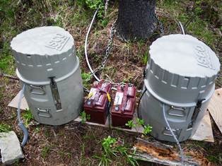
Level 1 – Automated continuous monitoring: water temp, dissolved Oxygen, electrical conductivity, pH, ORP, turbidity, & salinity using automated water quality sondes; continuous data (ice free periods from May to October).
Level 2 – Automated daily sampling using ISCO water samplers is conducted at all of our sites. This involves 1 composite sample for each ice free day consisting of 4; 250 ml sub-samples collected every 6 hr. These samples are then collected by field crews for subsequent analysis for suspended sediment and turbidity in the laboratory.
Level 3 – Full suite nutrients and cations/anions – Nitrogen (TN, TDN, NH+4, NO-3), Phosphorous (TDP, SRP, TP), K+, SO-4, Ca2+, Mg2+, Na+, Fe2+, Al3+ Cl-, silica, DOC/DIC, dissolved & suspended solids. Depth integrated samples are taken (along with discharge measurements) every 10 days during the spring snowmelt freshet, every 14 days during summer and fall months, and every monthly during winter. Manual water samples are also taken during periodic storm events which contribute large amounts of sediments and nutrients to streams as a result of higher streamflows and saturated soil conditions.
Stream Ecology
Because water quality in undisturbed regions of the Rocky Mountain headwaters region is typically high, nutrient concentrations are often low (oligotrophic or nutrient poor). However, land disturbance can increase both sediment and phosphorus (typically the limiting nutrient for plant growth) transport into streams and rivers. The association between sediment and phosphorus is because phosphorus binds to sediment, thus sediment is often a strong vector for phosphorus movement into streams, but sediment-phosphorus interactions also regulate in-stream storage and downstream transport of this limiting nutrient.
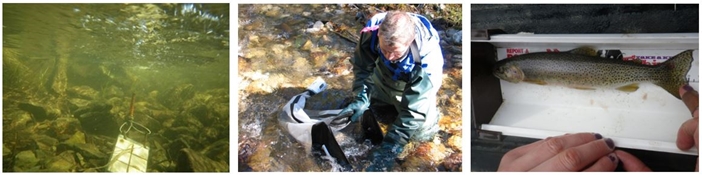
Elevated nutrient concentrations after wildfire produced near-immediate effects on algal growth after the Lost Creek wildfire. Monthly sampling of algae on the streambeds (or on porcelain tiles) is done monthly (ash-free dry mass and chlorophyll-a). Algae growth provides food for aquatic insects (benthic macro-invertebrates), thus the aquatic insect community (herbivores, detritivores, & predators) responds to changes in algal productivity because of the increased phosphorus after disturbance. Similarly, fish feed on these insects (i.e. the aquatic food chain can be affected). Our research had also included sampling both the insect and fish communities to describe these effects. Species composition and analysis of naturally occurring isotopes of nitrogen and carbon provide insight into food-chain linkages between algal growth dynamics with macro-invertebrate and fish community populations.